Book Tickets Online
About
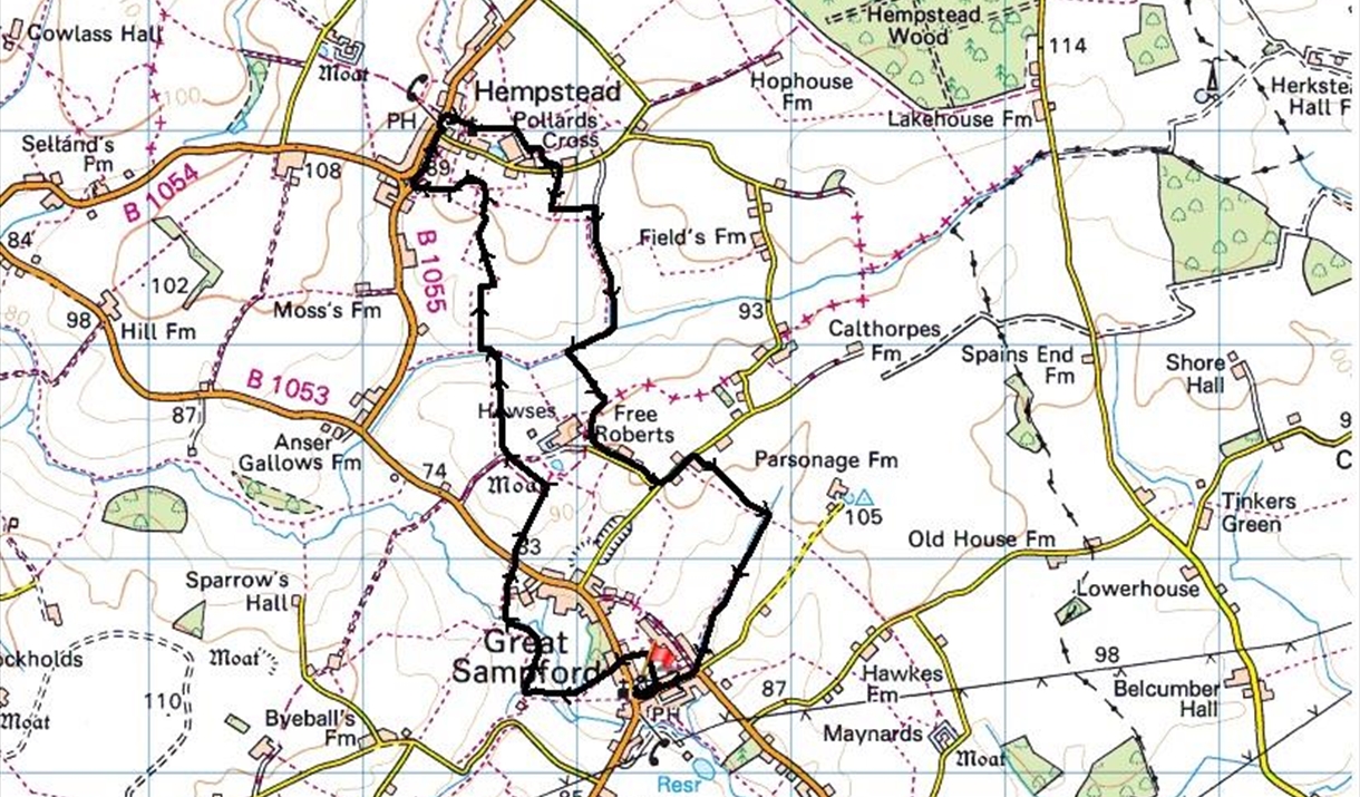
A circular walk through the North Essex countyside, the birthplace of legendary Highway Man Dick Turpin, from Great Sampford to Howses & Hempstead and back to Great Sampford via Free Roberts 6 miles (9.5 kms)
This walk starts at St. Michael’s Church, Great Sampford, CB10 2RS
OS Landranger Map 195 Grid Reference TL642353. Please park responsibly in the street. (Route directions updated July 2020)
- From the church cross the road and continue down the road opposite towards the Red Lion public house (now closed).
- Take the path to the left of the pub into the playing fields. Turn left past the tennis courts and then cross the road (B1053).
- Take the path between the houses and bear right when you enter the open field.
- Cross the bridge over the River Pant, cross two further bridges then bear half right through field. At path crossing in the field turn right and cross back over the river at the next bridge.
- Bear right and cross three horse paddocks through gates and then cross a field to the road (B1053).
- Cross the road and climb the steps and 400 yards ahead turn left through a gate.
- Pass through two more gates to reach a track with a cattle grid, on the right is Howses, a moated farmstead.
- Bear part left over a stile and continue with the hedge on your right, down a field with views of Hempstead church in the distance.
- Take a bridge over the stream and steps up a bank.
- Turn left at the top and then soon right up a field with a hedge on your left. Follow to the top of the field and round to take a left turn through a hedge. Cross the field to the corner by a hedge and follow path around the edge of the field.
- Then bear right and enter a paddock with hedge on your left.
- Cross two stiles (but which can be avoided by using the gap only a little further on) and head down the field to the road.
- Turn right on the road and after 50 yards bear right onto a byway past Wellyards.
- On reaching the road turn left to the Bluebell Inn, the birthplace of Dick Turpin.
- Turn right up the road then right again by the village hall and go through the churchyard to gap.
- Turn right after the second gate, past the pond and willow trees onto the road. Turn left on the road and right after 100 yards onto a path on the right, then left after 200 yards and walk alongside the hedge to the bottom of the field. Continue round to the right for 600 yards and then drop down to follow the River Pant on your left.
- Crossing a footbridge continue to keep to the field edge and then take the bridge over the river. Follow the path upwards. (If very wet divert further to the left, but continuing up to meet a track.) Turn right on to a green lane and follow to the road.
- Turn left, walk past Free Roberts and left again at the T-junction.
- Follow the road passing Bean Pods to Bean Pod Farm (also called Byatts Farm), turning right past farm buildings and on past fenced paddocks on the left and a hedge on the right, continue to a ditch on the right.
- Keeping the ditch on your right, turn right and continue for half a mile back towards Great Sampford crossing an earth bridge half way to continue with the ditch on your left. Turn right on to the road back to the church.


 next to an item to add it to your Itinerary basket. You will then be able to save, download, or share your itinerary.


